Geophysical Institute - the Affiliate of Vladikavkaz Scientific Centre of the Russian Academy of Sciences
Basic research
Creation of systems of complex geophysical observations in the region
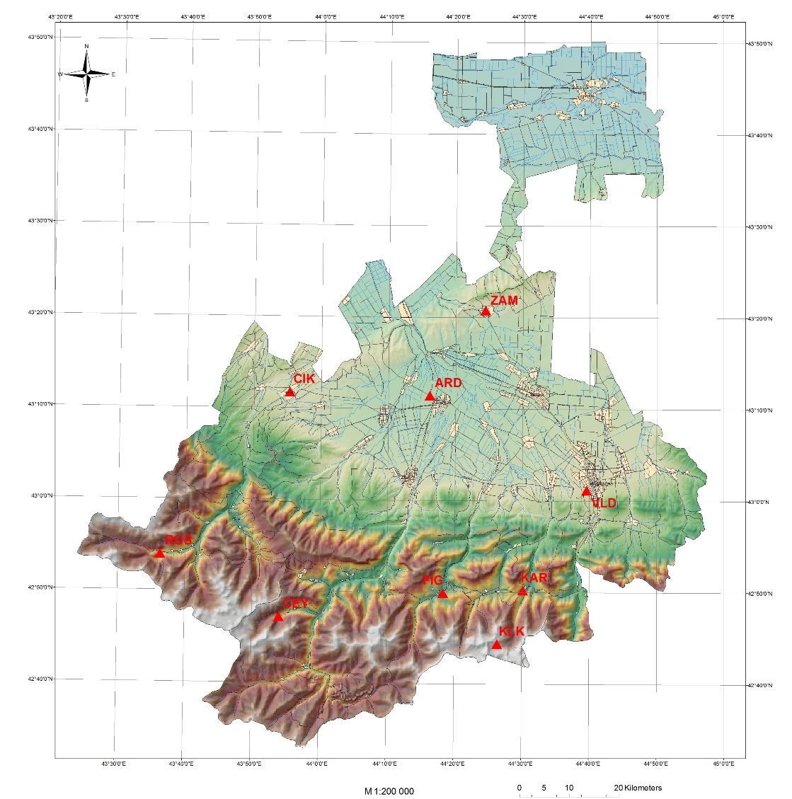
In 1999 the Institute organized a network of seismic observations. The network included the stations of Vladikavkaz (VLD), Chikola (CIK), Zamankul (ZAM), Tsei (CEY), Fiagdon (FIG), Ardon (ARD), Dzinaga (DIG). The specified network recorded the process of the Kolka Glacier collapse on September 20, 2002. In September 2003, a new station, Karmadon (KAR), was established. In September 2003, the Republican seismic local network in accordance with the Agreement between Geon LLC, the North-Caucasian Institute of Mining and Metallurgy (State Technological University) and Geophysical Institute was transformed into the “Karmadon Parametric Range” for instrumental observations of hazardous natural and man-made processes, in which it significantly differs from standard networks of seismic observations. In 2006 all the equipment were updated.
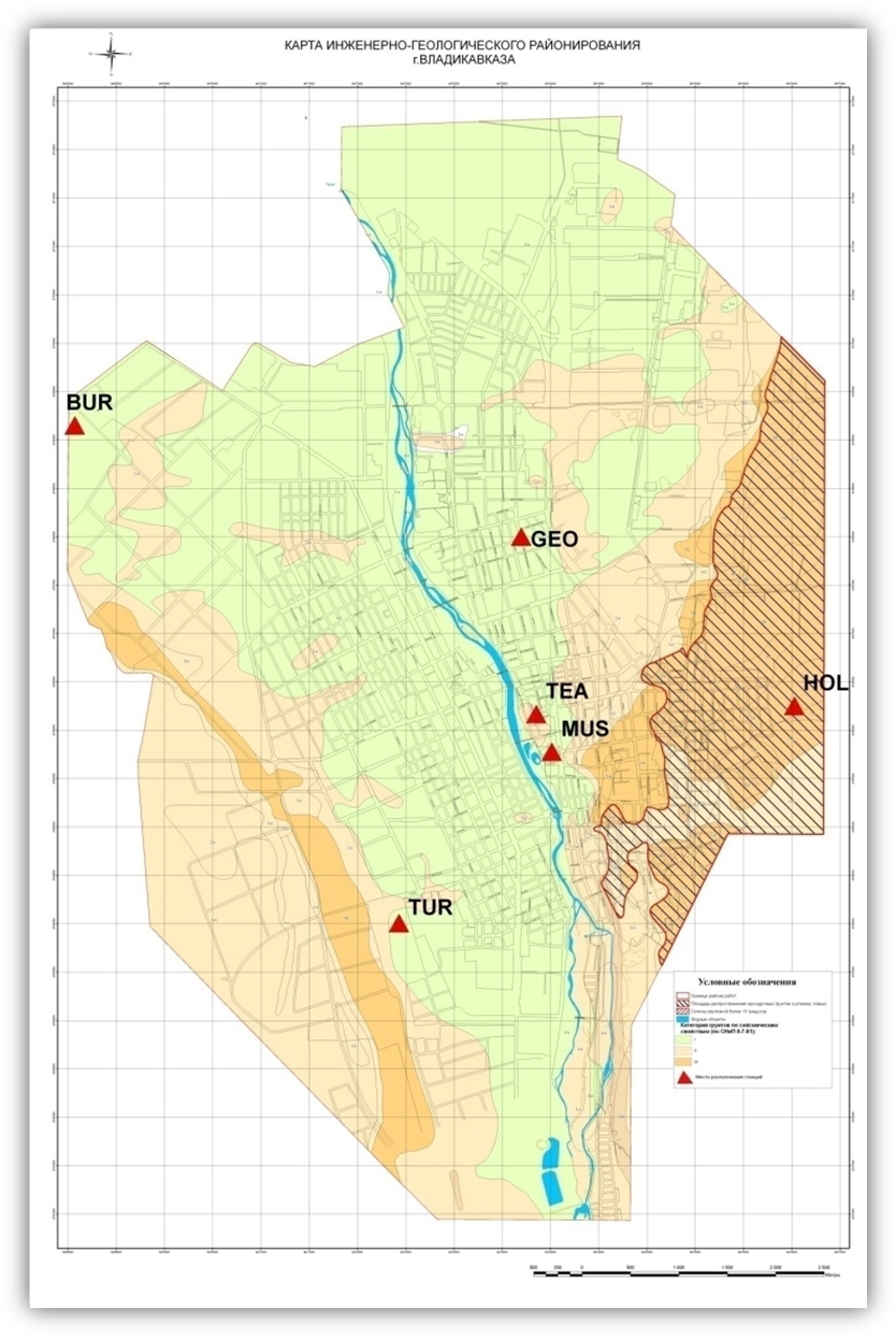
For the first time in the North Caucasus in 2004, a permanent network of engineering-seismological observations on sites with different ground conditions was created in the urbanized territory (Vladikavkaz).
In 2009 in cooperation with specialists from the Shmidt Institute of Physics of the Earth RAS a network of GPS-measurements from 4 points was organized and measurements were made to study the modern movement of the Vladikavkaz fault. At present, the forecasted GPS / GLONASS system of observations in the area of Vladikavkaz fault with a potential magnitude M = 6.5-7.1 has been created for the first time. System of additional series of points has been developed for the first 5-7 km in both directions from the fault to increase the reliability and accuracy.
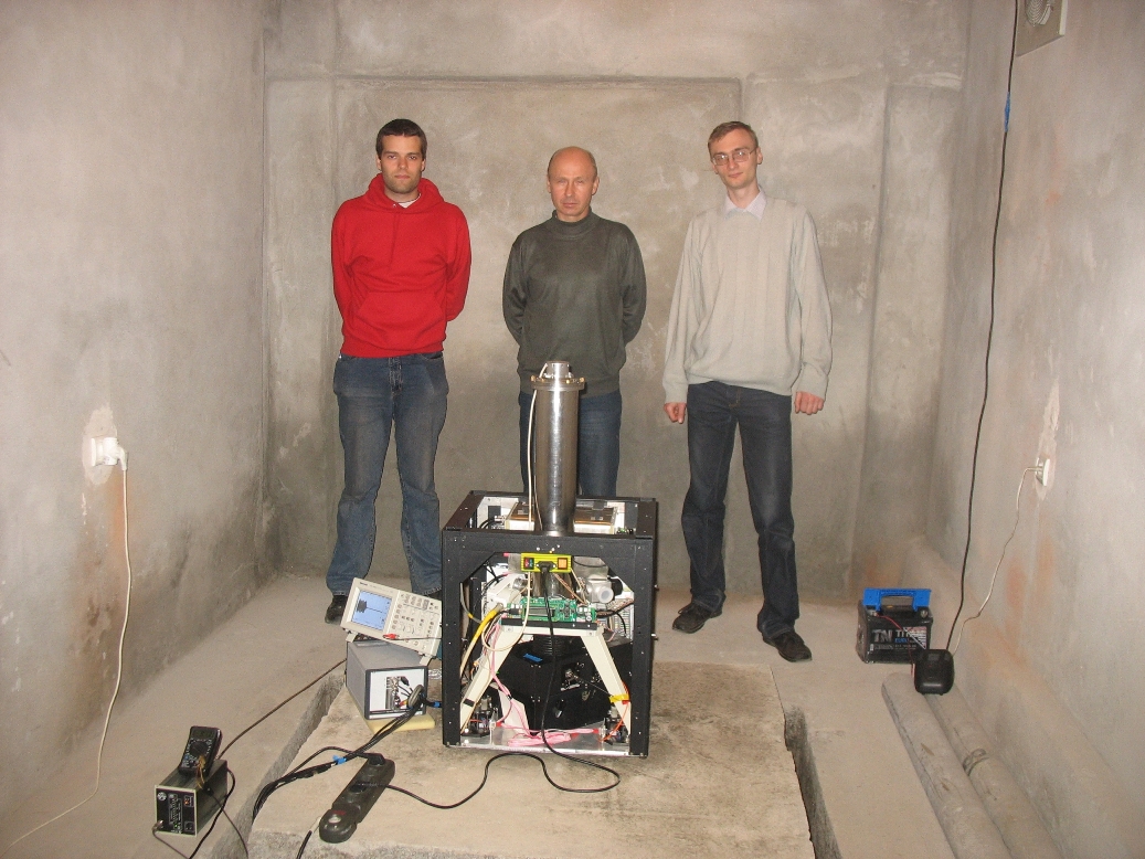
In 2009, together with the Moscow State University and Central Research Institute of Geodesy, Aerial Photography and Cartography, the site of high-precision gravimetric measurements was established on the territory of Geophysical Institute and absolute gravimeter measurements were made.
In 2012, the network of seismological observations of the “Karmadon Parametric Range "and an urbanized network of seismic observations" Vladikavkaz polygon" were modernized and expanded. In the area of the Kolka glacier at an altitude of 2,970 meters above sea level, the Kolka seismic station was installed. The station operates in the continuous recording mode, the time synchronization is carried out every day by GPS.
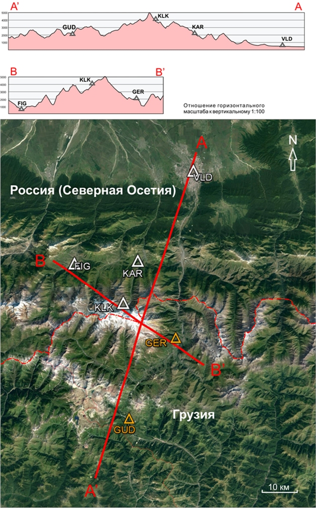
A system of instrumental monitoring of volcanic manifestations in the Kazbek volcanic center, including 4 seismic stations of the Geophysical Institute and 2 stations of the Georgian Seismological Service. The exchange of instrumental data will reveal a number of important characteristics of the Kazbek volcano and significantly increase the safety of life through adequate risk assessment and prediction of dangerous geological processes.
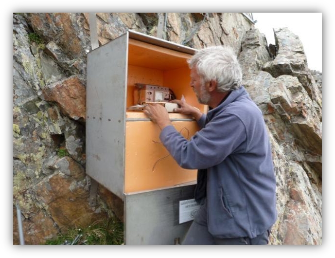
An experimental installation has been set up for the transmission of telemetric wireless information from the seismic station to the information collection center located in Geophysical Institute. The algorithms and the corresponding software were developed, which makes it possible to poll the Delta-Geon registrar on the initiative of the data collection center at a given interval or on request. In the telemetry complex, an autonomous power supply unit based on a solar module of the frame type with a power of 40 W and battery pack of 40 AH was designed and built.
On the basis of new theoretical concepts, using the microwave generator in cooperation with the North-Caucasian Institute of Mining and Metallurgy (State Technological University), an original seismic receiver of medium vibrations with improved characteristics and high stability was developed. An effective sample of the geophone was constructed. The developed designs of seismic sensors allow recording vibrations of an amplitude up to 0.1 μm.
Karmadon parametric range
Kazbek volcanic center monitoring system
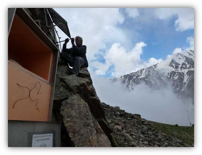
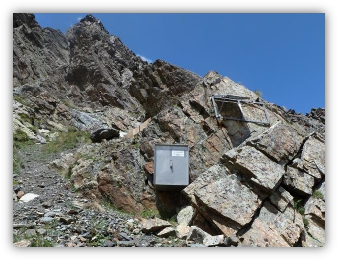
Seosmic station “Kolka” at altitude 2970 m
Absolute gravimetric measurements
Permanent engineering seismivc network on urbanized territory
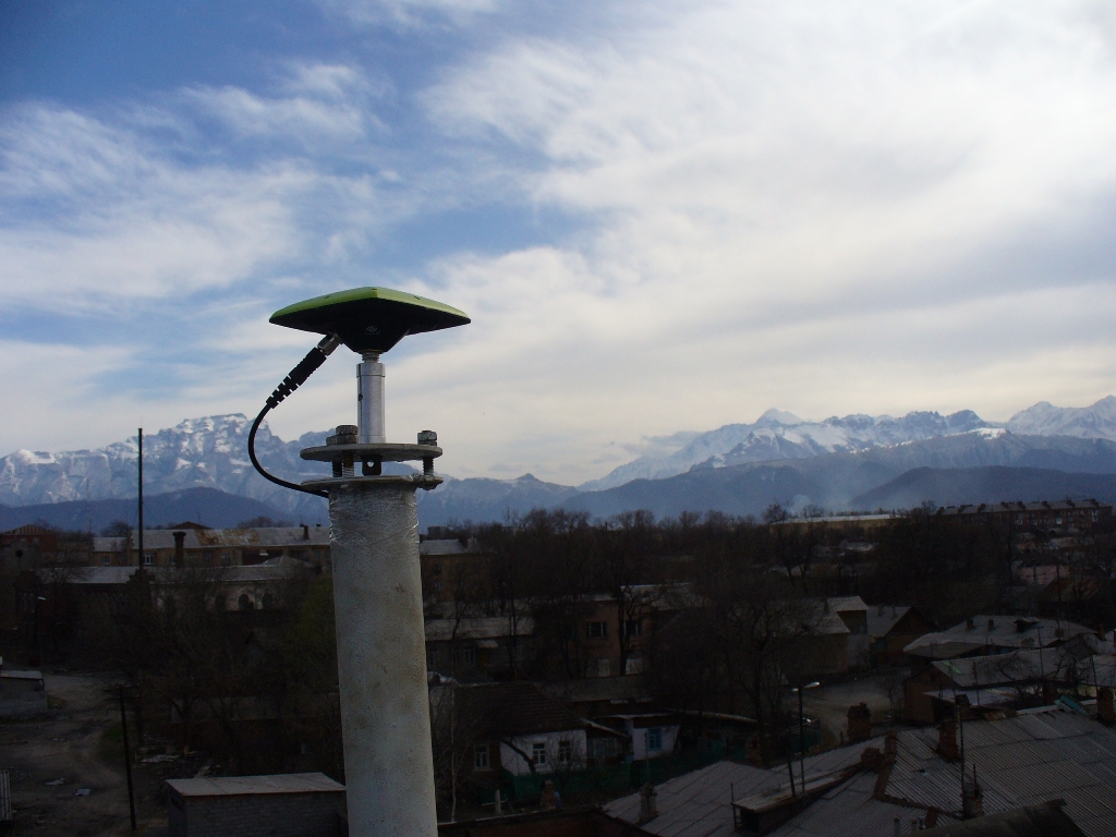
Base GPS station, located in GPI VSC RAS
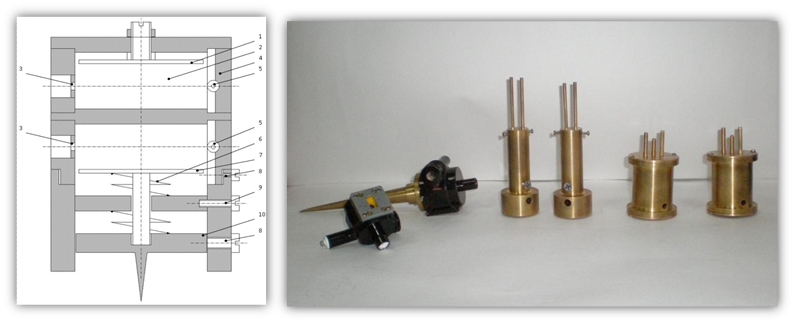
New type of seismic sensor
Assessment of seismic hazard and seismic risk of urbanized territories
A complex method for assessing the seismic hazard of the territory was developed on the basis of taking into account the features of the relief, types and nonlinear properties of soils at a changing level of seismic impact. For the first time in Russia, probabilistic maps (1, 2, 5, 10%) of the seismic hazard of the territory of North Ossetia-Alania were constructed using the SEISRisk-III software package in GIS technologies. The parameter "quality factor (rating) of soil conditions" was introduced. For the first time in Russia, the approach based on taking into account the physical mechanisms of the focus was used, and the computer program FINSIM (I. Beresnev), which made it possible to calculate seismic effects in the form of synthetic accelerograms from the Vladikavkaz fault, which were compared with records of digital stations. The concept of "weighted average period of vibrations" is introduced, the use of which has allowed to significantly reduce the spread at correlation ratios. New empirical formulas have been obtained that have no analogues in the world, which allow one to estimate the change in the calculated intensity on the basis of physical nonlinearity and inelasticity of soils. A new concept of the "relief factor" has been introduced and a new empirical formula has been proposed that has no analogues in the world, to directly take into account the influence of the relief on the formation of the earthquake intensity.
Based on the analysis of data from instrumental and numerical studies, the main factors that form the level of intensity of earthquakes in mountain regions are established. The analysis of existing indicators of instrumental intensity was carried out: Arias, Ang, Hausner, Zaalishvili. The energy indices of the seismic action and the "damageability" of physical systems are determined from the databases of strong movements. Correlative relationships between parameters of soil movement - indicators of the potential for "damageability" of the object and their relationship to the level of the manifested intensity are established.
The decrease of the seismic risk of building in the design of the basement floors was studied on the basis of the use of an effective seismic isolation scheme in the North Caucasus. The scheme of seismic isolation of buildings and structures on kinematic bearings with elastic horizontal connection was developed for the first time.
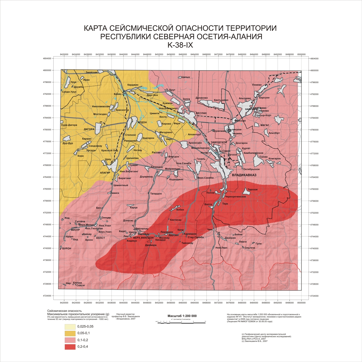
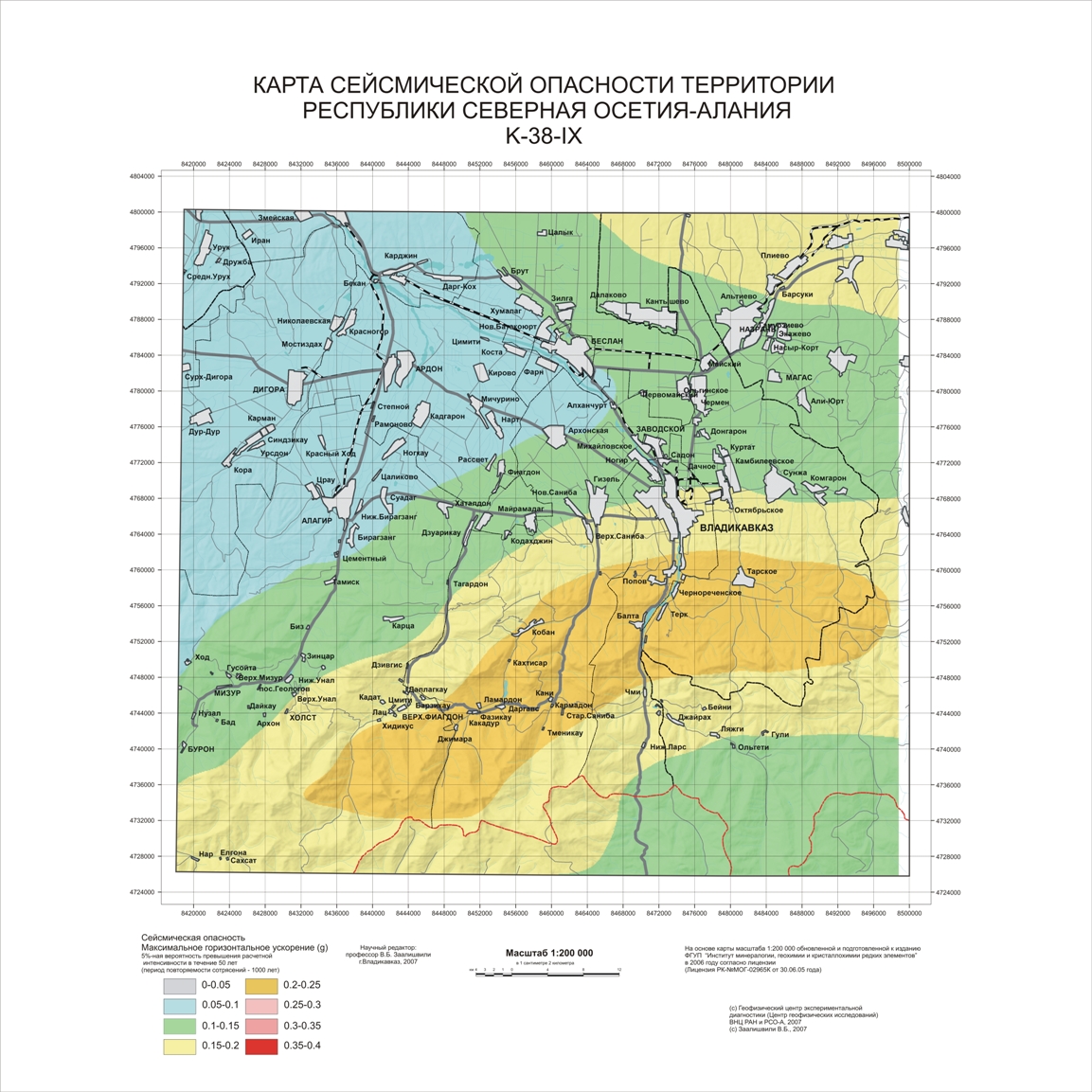
Probability maps of seismic hazard of the territory of the North Ossetia-Alania in MSK scale and PGA values
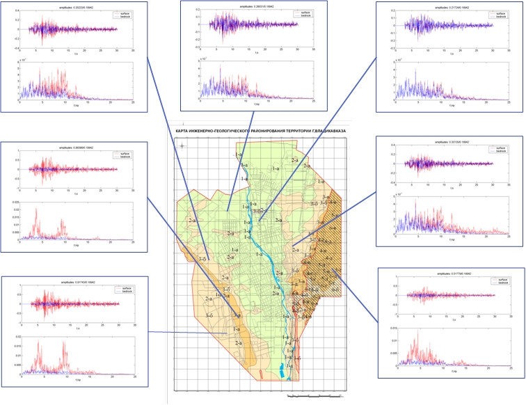
Site effects at different parts
Investigation of the stress-strain state of a rock massif at technogenic impacts
The generalization of man-made voids formed in the zone of combined natural and technogenic impact of the operation of the “Sadonskoye” deposits is carried out. Quantitative characteristics of the activity of their exploitation are obtained, the regularities of the processes of formation of anthropogenic disturbance of subsoil are established. Information on the technology of field exploitation is generalized and the probability of catastrophic reaction of massifs to technogenic impact in conditions of seismic hazard is estimated. The scientific foundations of the integration of force fields in arrays on the priority criterion for reducing losses and dilution of ores during the development of rock massifs of complex structure are created. To take into account seismic impacts in the massif (mines, etc.), a special seismic coefficient was introduced.
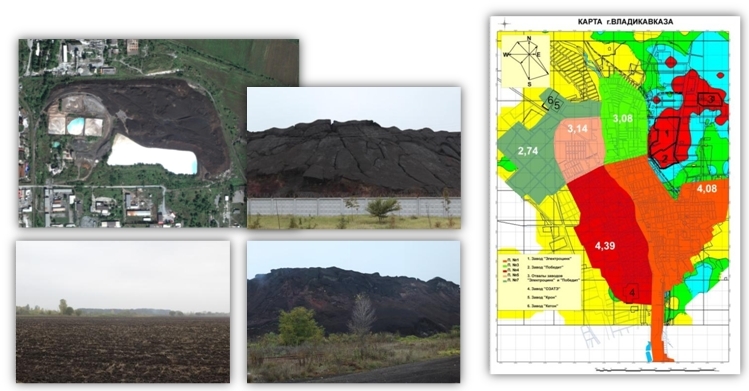
The contamination of the territory of Vladikavkaz with heavy metals has been studied. The incidence of neoplasms in the population of Vladikavkaz over the past 5 years has been studied. The analysis of the obtained results is carried out taking into account the wind rose. A map of pollution and incidence of neoplasms using the method of polyclinic zoning is made. It is planned to conduct research on the studied indicators in two districts of the Republic whose population is exposed to adverse environmental factors.
A methodology for assessing environmental risk in ore mining has been developed. The analysis of factors of technogenic activity in a zone of extraction and processing of minerals in the conditions of high mountains is carried out. Geochemical studies of the Sadonsky mine area, as well as bioassays (agricultural products) in the mining impact zone have been carried out. An analysis is made of the health status of the population living in the zone affected by the mining industry. Monitoring of the state of technogenic deposits of terraced and floodplain areas of the mountain river valleys of the Fiagdon and Ardon rivers is underway.
A technology has been developed for the utilization of tails of ore redistribution with leaching of tailings activated in disintegrators, as a radical method of recovery lost under technogenic influence, and environmental properties. Environmental efficiency is due to the reduction of damage from the storage of tailings, profits from metal processing, raw materials for the construction industry and the preservation of socium and biota.
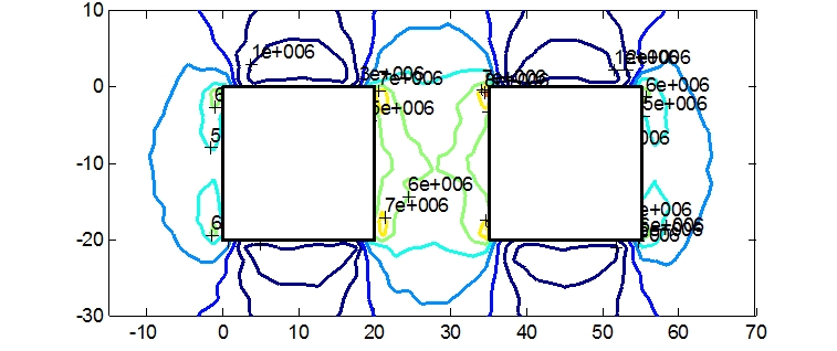
Calculation of the stressess in pillar
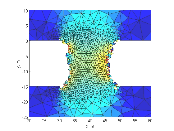
FEM model of pillar destruction
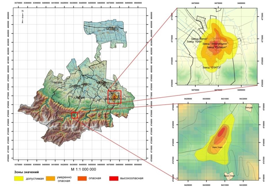
Map-scheme of geochemical pollution areas
Geoecological investigations of mining tailings and morbidity on the surrounding territory
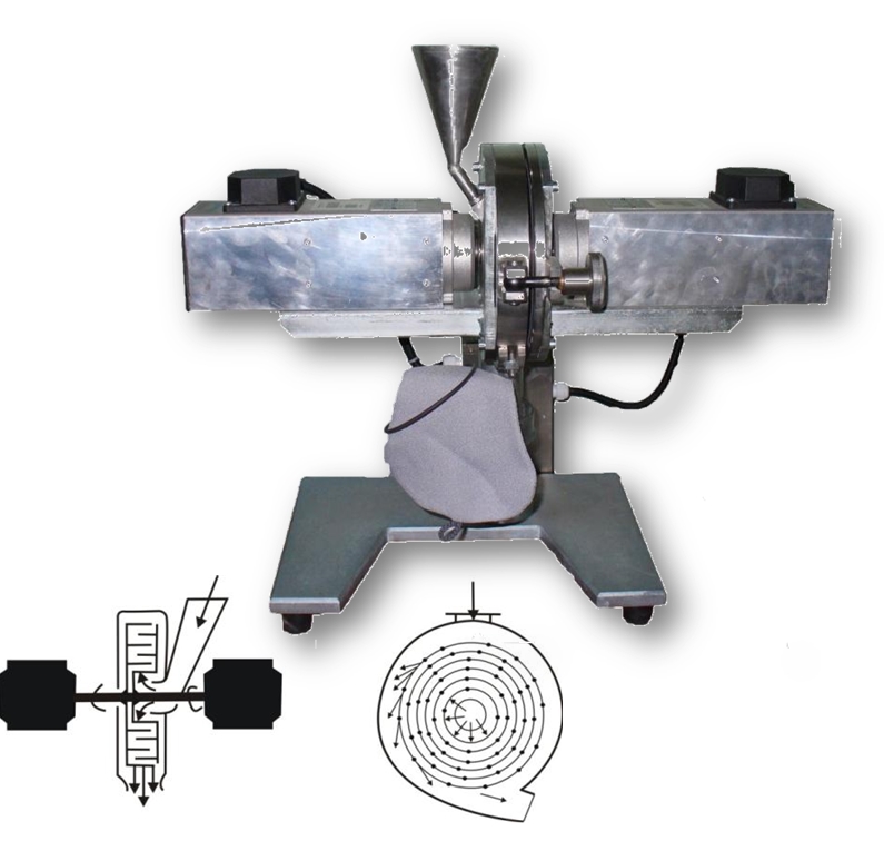
An innovative technology of combined mechanochemical activation of metal extraction from substandard raw materials has been developed
Geological and geophysical aspects of the sustainable development of mountain areas
A model of the deep crustal structure in the region of North Ossetia and the adjacent territory was created. Field work was performed to establish the spatial position of the deep faults by the method of microseismic sounding (MMZ) along the profiles "Tskhinvali-Roksky Tunnel - Alagir-Elhotovo" and "Upper Zgid-Unal". Recommendations are given for monitoring dangerous geological processes in the zone of the Ardon fault. The analysis of available data on the geological structure of the mountainous Ossetia with the purpose of studying the deep structure, the search for oil deposits and other tasks is carried out. The electronic versions of the gravity anomaly map for the North Caucasus and North Ossetia, maps of magnetic anomalies have been compiled. The tasks of interrelation of the deep structure of mountainous Ossetia with seismicity of the territory are formulated.
The analysis of the results of geophysical studies of various characteristics of the volcanic centers of the North Caucasus, in particular, in the Central Caucasus in the form of area gravimetric and aeromagnetic surveys of scales 1: 200000-1: 50000, as well as depth studies on regional profiles by the methods of exchange waves of earthquakes (MOVZ) and magnetotelluric Soundings (MTZ); As a result of research it is shown that Elbrus volcano is characterized by magmatic focus and magmatic chamber, at the same time for Kazbek mountain, according to the studied data there are no signs of a volcano; Kazbek should be considered, in contrast to Elbrus, in extreme cases, like an extinct volcano.
For the industrial use of the thermal energy of the Kazbek volcanic center, geothermal fields have been investigated in the Kolka (Russia) and Devdorak (Georgia) glaciers; An analysis of the experience of similar geothermal studies in the Far East and abroad has made it possible to formulate the features of planning and conducting similar studies;
Based on the study and analysis of the data of the strongest earthquakes in the world, a database of strong motions (the number of events up to 50000) was created on-line, on the basis of which a new instrumental calculation method of seismic microzoning was developed. The method allows, depending on the specific engineering seismological and ground conditions, based on the use of the database of strong motions, to form the expected instrumental records of seismic influences. The new method allows obtaining physically more reasonable results.
An approximate analytical method for solving nonlinear initial-boundary problems of seismic oscillations of a soil column in the form of an elastic-viscous continuous medium with nonlinear properties is developed. In the calculations, the influence of the distributed mass imitating the urban development and the seismic effect at some depth in the form of an impulse function was taken into account. A physics-mathematical model of joint seismic oscillations of a high-pressure dam and water in a reservoir is drawn up. It represents a spatial contact boundary value problem for systems of differential equations of oscillatory movements of a dam and water in a reservoir. Calculation formulas for calculating the frequencies of the basic forms of natural oscillations of the system are obtained.
A 25-cell binary sedimentary system of minerals has been developed. This classification in geology was developed for the first time. It is the basis for solving a wide range of geological issues based on the application of quantitative terrigenous-mineralogical indicators. For the first time, the reverse geological problem of terrigenous mineralogy has been solved through the consistent application of two single-factor models: 1) by the quantitative ratio of the different in chemical stability of minerals having the same or similar hydro-aerodynamic stability (for example, by the ratio of quartz and feldspar, zircon and magnetite, etc.) and 2) to quantify the relationship of various hydro- aerodynamics stability minerals having the same or similar chemical stability.
The study of the change in the quality of groundwater at the operating intakes of groundwater. The horizons of groundwater pollution have been identified and outlined by the activities of numerous industrial enterprises operating within the Ossetian foothill depression. Foci of pollution of underground waters due to penetration of industrial wastes of factories of JSC "Electrozinc" and JSC "Pobedit" have been determined. The study and analysis of the peculiarities of the operation of the Ordzhonikidzevskoe groundwater field supplying the republic's capital with drinking water revealed violations of the field exploitation regime, which provokes changes in the hydro-geological conditions of the field for the worse. The results of the study of hydrogeological conditions form the basis for determining the criteria for seismic microzoning of settlements in the republic.
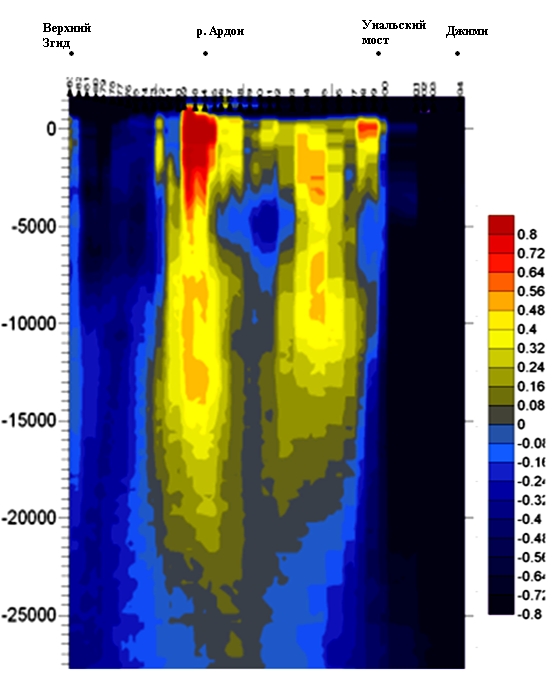
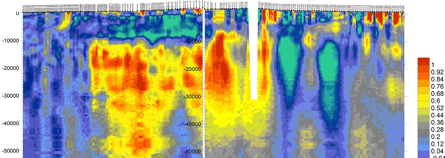
method of microseismic sounding
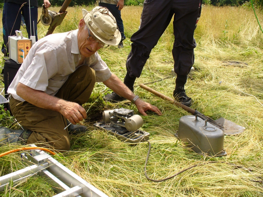
Field experiments on nonlinear soil phenomena
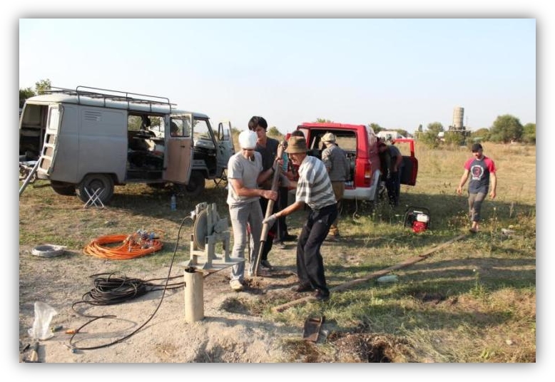
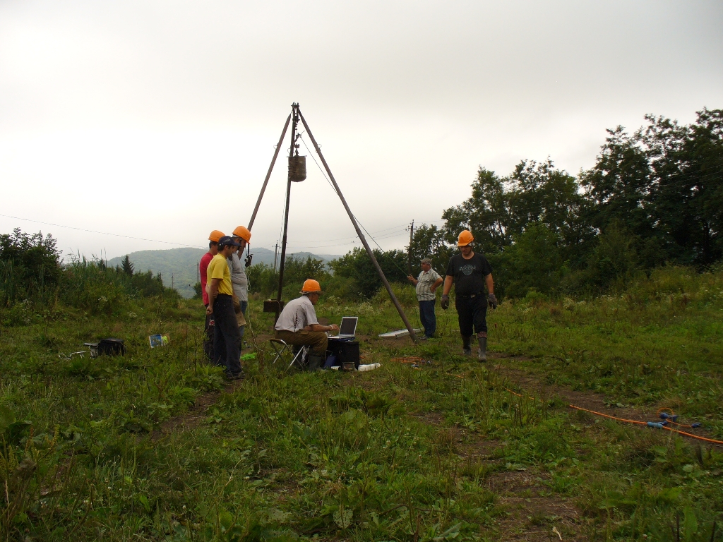
Field works
Seismic risk assessment in one of the parts of Vladilavkaz city
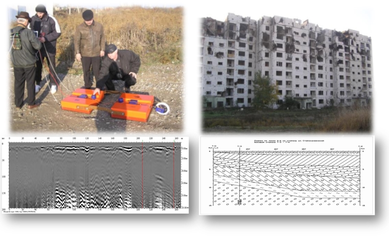
GPR exploration of site conditions and state of damaged buildings in Grozny city
Investigation of dangerous endogenous and exogenous processes and associated dangerous geological processes
The collection, processing and analysis of materials on the geological structure of the Kazbek-Dzhimaraysky region and adjacent territories of the Central Caucasus (stratigraphy, lithology, magmatism, tectonics, structural-formational zoning, etc.) were performed. Collection, processing and analysis of historical and glaciological materials on the cyclic self-sustained development of the pulsating Kolka Glacier, the specificity of the catastrophic pulsations in 2002, and the possible role of seismotectonics in their preparation and manifestation were collected, processed and analyzed. The use of aerospace survey data and modern computer technologies allowed us to reconsider a number of traditional provisions and to re-evaluate the mechanisms of a number of modern exogenous processes. The most important features of the preparation of catastrophic ejection of ice-rock material within the Kolka Glacier and the periglacial zone are established: intensification of collapses on the Kolka Glacier, a decrease in the level of surface waters (infiltration effect or the effect of a "dried-up river"), etc. (A total of 13 signs). This can become a standard forerunner of the gas-dynamic discharge of the glacier and should serve as the basis for a system for monitoring the state of the glacier and the glacial zone in order to exclude its sudden activity.
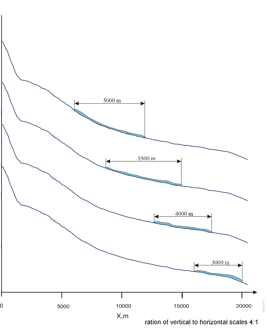
The unique records of the Kolka glacier fault obtained by the stations of the Institute and the adjacent territory, as well as those obtained in 2006 from the GS RAS, were studied in detail. The analysis of parameters of all previous events is performed with the help of wavelet analysis, etc. A modern method of monitoring dangerous geological phenomena, including geodynamic features of the Kolka glacier and other exogenous processes, has been developed. The peculiarities of the Kolka glacier movement are studied on the basis of taking into account the geomorphological conditions of transit according to instrumental data. The main stages of the movement have been specified, 15 special points of the process of descent and speed of movement have been determined. It was established that during the descent the length of the ice-rock flow varied from 5 to 3 km at an altitude of 150-200 m. The seismic intensity of the shock of the ice-rock mass in the region of the Karmadon Gate was estimated to be VI points on the MSK-64 scale.
On September 20, 2002, soil and vegetation cover studies were carried out in the vicinity of the Kolka glacier. In the post-catastrophic period, there is a restoration of the soil-vegetation cover in the transit zone of the high-speed avalanche flow and glacial mudflow. The paradox of the situation is that the observed processes, normally characteristic of high mountains, occur in the middle reaches. A complex of works of monitoring the transformation of the biota of the Zaramagh semiarid depression of the Southern Jurassic depression under the influence of the reservoir and other objects of Zaramagskaya HPP. The results of the study will allow to develop a reference state of the plant environment for establishing the features of the influence of geological processes on the environment. The study of the consequences of glacial catastrophes in the valley of the river. Genaldon and the prediction of these disasters are based, as a rule, on abiotic indicators. Meanwhile, for these purposes, a number of biological indicators (especially phytoindicators) can be used. In the context of geoecological monitoring of the valley of the river. Genaldon conducted a search for phytoindicators, marking in the landscape the consequences of the Kolka glacier on September 20, 2002 and previous glacial catastrophes. As a result, it has been established that some plant communities that are sufficiently clearly identified in landscapes can be effectively used for phytoindication of the effects of the glacial event on 20.09.2002 and long-term forecasting of glacial catastrophes in the Genaldon Valley.
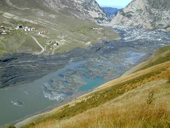
Glacier Kolka fall on September 20, 2002
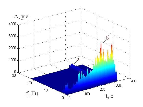
Wavelet analysis of glacier Kolka fall record (station FIG)
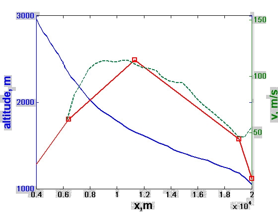
Glacier Kolka fall on September 20, 2002. Variations of ice-rock avalanche velocity along trace 1 – transit zone section; 2 – velocities based on seismological data (main points); 3 – calculated velocities
Glacier Kolka fall on 20 september 2002. Dynamics of changes of ice-rock mass length on different stages of movement